Introduction
Print section
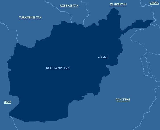
Afghanistan,
officially Islamic State of Afghanistan, republic in southwestern Asia, bounded on the north by Turkmenistan, Uzbekistan, and Tajikistan; on the east by China and the part of the disputed territory of Jammu and Kashmir controlled by Pakistan; on the south by Pakistan; and on the west by Iran. Afghanistan was a monarchy from 1747 to 1973, when the king was overthrown by military officers and the country was proclaimed a republic; the republic dissolved in 1992 as the country erupted in civil war. Afghanistan lies across ancient trade and invasion routes from Central Asia into India. This position has been the greatest influence on its history because the invaders often settled there. Today the population includes many different ethnic groups. Most of the present borders of the country were drawn up in the 19th century, when Afghanistan became a buffer state, or neutral zone, between Russia and British India. Kabul is the capital and largest city.
II. Land and Resources
Print section
Afghanistan is shaped roughly like a clenched fist with the thumb of the Vakhan Corridor extended out to the northeast. Afghanistan covers an area of 652,225 sq km (251,825 sq mi). Its maximum length from east to west is about 1,240 km (about 770 mi); from north to south it is about 1,015 km (about 630 mi). The northwestern, western, and southern border areas are primarily desert plains and rocky ranges, whereas the southeast and northeast borders rise progressively higher into the major, glacier-covered peaks of the Hindu Kush, an extension of the western Himalayas. The northern border is formed by the Amu Darya river and its tributary, the Panj.
A. Natural Regions
Print section
High mountains cover much of Afghanistan, with about one-half of the land over 2,000 m (6,600 ft) in elevation. Small glaciers and year-round snowfields are common. The highest peak, Nowshak (Noshaq), rises 7,485 m (24,557 ft) on the northeast border and is a lower spur of the Tirich Mir peak in Pakistan. The Hindu Kush range extends across the country in a southwesterly direction from the Vakhan Corridor almost to the Iranian border. From the Hindu Kush, other lower ranges radiate in all directions. Some of the major mountain systems include the Pamirs in the upper northeast of the Vakhan Corridor, the Badakhshan Ranges in the northeast, the Paropamisus Range in the north, and the Safed Koh range, which forms part of the frontier between Afghanistan and Pakistan. Lowland areas are concentrated in the south and west and include the Turkistan Plains, the Herat-Ferah Lowlands of the extreme northwest, the Sistan Basin and Helmand River valley of the southwest, and the Rigestan Desert of the south.
Except for the river valleys and a few places in the lowlands where underground fresh water makes irrigation possible, agriculture is difficult. Only 12 percent of the land is cultivated. Moreover, a war with the Union of Soviet Socialist Republics (USSR) in the 1980s and the subsequent civil war in the 1990s left some of that land unusable because of neglect, the planting of explosive mines, and other problems. In general, sheep and goat grazing make up the main agricultural land use. In eastern and southeastern Afghanistan, forest lands amounted to 1.4 million hectares (3.5 million acres), or 2 percent of the country's land area in 1995. The ravages of war, the scarcity of fuel, and the need for firewood for cooking and heating have caused rapid deforestation.
Because Afghanistan has so many high mountains, the passes through them have been of profound importance in both the history of invasion of the country and in commerce. In the 320s BC Alexander the Great invaded the country through the Kushan Pass (about 4,370 m/about 14,340 ft) in the west and left it to the east through the low Khyber Pass (1,072 m/ 3,517 ft) to invade India. These same passes were used by the Mughal emperor Babur to conquer both Afghanistan and India in the 1500s. The famous Salang Pass (3,880 m/12,720 ft) and its Soviet-built tunnel in the central Hindu Kush was one of the main routes the Soviets used to invade Afghanistan in 1979.
B. Rivers and Lakes
Print section
Many of Afghanistan's major rivers are fed by mountain streams. The Amu Darya on the northern frontier receives water from two main tributaries, the Panj and the Vakhsh, which rise in the Pamirs. The Amu Darya is the only navigable river in Afghanistan, though ferry boats can cross the deeper areas of other rivers. The Harirud River rises in central Afghanistan and flows to the west and northwest to form part of the border with Iran. The long Helmand River rises in the central Hindu Kush, crosses the southwest of the country, and ends in Iran. It is used extensively for irrigation and agriculture, although in recent years its water has experienced a progressive build up of mineral salts, which has decreased its usefulness. Most of the rivers end in inland seas, swamps, or salt flats; the Kabul River is an exception. It flows east into Pakistan to join the Indus River, which empties into the Indian Ocean.
Afghanistan's lakes are small in size and number, but include Lake Zarkol in the Vakhan Corridor along the Tajikistan border, Shiveh in Badakhshan, and the saline Lake Istadeh-ye Moqor, located south of Ghazni. The country also has a few salt marshes at the limits of the Helmand drainage on the western border with Iran. The most important dams and reservoirs in Afghanistan are the Kajaki Reservoir on the Helmand, the Arghandab Dam on a tributary of the Helmand, the Sardeh Dam on the Ghazni River, and the Kelagay Dam on the Darya-ye-Qondoz tributary of the Amu Darya. Prior to the civil war, less than 10 percent of the country's hydroelectric potential had been developed. After the war began, hydroelectric production dropped off severely as turbines were destroyed, floodgates blown open, and transmission lines brought down. Private diesel-fired generators were about all that remained of 75 years of electric development. In 1998 Afghanistan generated only 430 million kilowatt-hours of electricity.
C. Plant and Animal Life
Print section
Plant life in Afghanistan is sparse but diverse. Common trees in the mountains are evergreens, oaks, poplars, wild hazelnuts, almonds, and pistachios. The plains of the north are largely dry, treeless steppes, and those of the southwestern corner are nearly uninhabitable deserts. Common plants in the arid regions include camel thorn, locoweed, spiny restharrow, mimosa, and wormwood, a variety of sagebrush. The wild animals of Afghanistan include 123 mammal species, some of which are nearing extinction. The most seriously endangered are the goitered gazelle, leopard, snow leopard, markor goat, and Bactrian deer. Other wild animals of Afghanistan include Marco Polo sheep, urials, ibex, bears, wolves, foxes, hyenas, jackals, and mongooses. Wild boar, hedgehogs, shrews, hares, mouse hares, bats, and various rodents also occur. Some 460 bird species are found in Afghanistan, with more than 200 breeding there. Flamingo and other aquatic fowl breed in the lake areas south and east of Ghazni. Ducks and partridges are also common, but all birds are hunted widely and many are becoming uncommon, including the endangered Siberian crane.
D. Climate
Print section
Most of Afghanistan has a subarctic mountain climate with dry and cold winters, except for the lowlands, which have arid and semiarid climates. In the mountains and a few of the valleys bordering Pakistan, a fringe effect of the Indian monsoon, coming usually from the southeast, brings moist maritime tropical air in summer. Afghanistan has clearly defined seasons; summers are hot and winters can be bitterly cold. Summer temperatures as high as 49° C (120° F) have been recorded in the northern valleys. Midwinter temperatures as low as -9° C (15° F) are common around the 2,000-m (6,600-ft) level in the Hindu Kush. The climate in the highlands varies with elevation. The coolest temperatures usually occur on the heights of the mountains.
Temperatures often range greatly within a single day. Variations in temperature during the day may range from freezing conditions at dawn to the upper 30°s C (upper 90°s F) at noon. Most of the precipitation falls between the months of October and April. The deserts receive less than 100 mm (4 in) of rain a year, whereas the mountains receive more than 1,000 mm (40 in) of precipitation, mostly as snow. Frontal winds sweeping in from the west may bring large sandstorms or dust storms, while the strong solar heating of the ground raises large local whirlwinds.
E. Natural Resources
Print section
Despite a lengthy history of small-scale mining of gems, gold, copper, and coal, systematic exploration of Afghanistan's mineral resources did not begin until the 1960s. In the 1970s Afghanistan was discovered to have a wide variety of mineral resources, but only coal, iron ore, copper ore, and gemstones were targeted for development. Natural gas fields are scattered throughout much of Afghanistan. Recent analysis by the United States Geological Survey has indicated significant unexploited oil reserves in the north as well. After their invasion of Afghanistan in 1979, the Soviets endeavored to export some of the country's resources to the USSR. Natural gas, for example, was exported by pipeline across the Amu Darya into the USSR in the 1980s. Ongoing hostilities, however, severely hampered this effort and finally cut off the natural gas export. By the mid-1990s there was little mineral or oil and gas extraction.
F. Environmental Issues
Print section
Afghanistan has long been a land of marginal environment—too dry and too cold for much life. Thousands of years of environmental stress by the country's people have dramatically altered the landscape and caused extensive environmental destruction. Because the Afghan people lack the financial means to purchase fuel, they must cut trees, uproot shrubs, and collect dung for burning. Domestic animals overgraze the range. The result is extensive soil erosion by water and wind. Long-term irrigation without flushing has added salt to much of the arable land and destroyed its fertility. Polluted water supplies are common, except in the high mountain regions where few people live permanently. Ancient writings and archaeological evidence show that once rich areas of forest and grassland have been reduced to stretches of barren rock and sand. The government of Afghanistan began to recognize environmental problems in the 1970s with the help of the United Nations and other international agencies. The pressures of the war, however, have diverted attention from these issues and further aggravated the country's environmental state.
http://www.khatamolanbiya.com
|